


Erving Precinct 1, Franklin County, Massachusetts
About
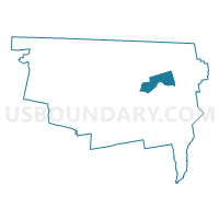
Outline

Summary
| Unique Area Identifier | 594137 |
| Name | Erving Precinct 1 |
| County | Franklin County |
| State | Massachusetts |
| Area (square miles) | 14.39 |
| Land Area (square miles) | 13.82 |
| Water Area (square miles) | 0.58 |
| % of Land Area | 96.00 |
| % of Water Area | 4.00 |
| Latitude of the Internal Point | 42.61341770 |
| Longtitude of the Internal Point | -72.42642740 |
Maps

Graphs
Select a template below for downloading or customizing gragh for Erving Precinct 1, Franklin County, Massachusetts


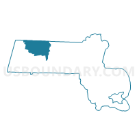
Neighbors
Neighoring Voting District (by Name) Neighboring Voting District on the Map
- Gill Precinct 1, Franklin County, MA
- Montague Precinct 2, Franklin County, MA
- Northfield Precinct 1, Franklin County, MA
- Orange Precinct 1, Franklin County, MA
- Warwick Precinct 1, Franklin County, MA
- Wendell Precinct 1, Franklin County, MA
Top 10 Neighboring County Subdivision (by Population) Neighboring County Subdivision on the Map
- Montague town, Franklin County, MA (8,437)
- Orange town, Franklin County, MA (7,839)
- Northfield town, Franklin County, MA (3,032)
- Erving town, Franklin County, MA (1,800)
- Gill town, Franklin County, MA (1,500)
- Wendell town, Franklin County, MA (848)
- Warwick town, Franklin County, MA (780)
Top 10 Neighboring Place (by Population) Neighboring Place on the Map
Top 10 Neighboring Elementary School District (by Population) Neighboring Elementary School District on the Map
- Orange School District, MA (7,839)
- New Salem-Wendell School District, MA (1,838)
- Erving School District, MA (1,800)
Top 10 Neighboring Secondary School District (by Population) Neighboring Secondary School District on the Map
- Ralph C. Mahar School District, MA (10,911)
- Gill-Montague School District in Erving (7-12), MA (1,800)
Top 10 Neighboring Unified School District (by Population) Neighboring Unified School District on the Map
Top 10 Neighboring State Legislative District Lower Chamber (by Population) Neighboring State Legislative District Lower Chamber on the Map
- First Franklin District, MA (42,424)
- Second Franklin District, MA (40,959)
- Second Berkshire District, MA (40,125)
Top 10 Neighboring State Legislative District Upper Chamber (by Population) Neighboring State Legislative District Upper Chamber on the Map
- Worcester, Hampden, Hampshire & Franklin District, MA (163,941)
- Hampshire & Franklin District, MA (156,938)
Top 10 Neighboring 111th Congressional District (by Population) Neighboring 111th Congressional District on the Map
Top 10 Neighboring Census Tract (by Population) Neighboring Census Tract on the Map
- Census Tract 402, Franklin County, MA (4,340)
- Census Tract 405.01, Franklin County, MA (4,264)
- Census Tract 407.02, Franklin County, MA (4,224)
- Census Tract 404, Franklin County, MA (3,428)
- Census Tract 403, Franklin County, MA (3,032)
Top 10 Neighboring 5-Digit ZIP Code Tabulation Area (by Population) Neighboring 5-Digit ZIP Code Tabulation Area on the Map
- 01364, MA (7,969)
- 01360, MA (3,032)
- 01354, MA (1,500)
- 01344, MA (1,498)
- 01349, MA (1,091)
- 01379, MA (813)
- 01378, MA (774)